
The Great American Road Trip - Chapter 3
by Michael S. True
May 29-June 7
Continuing the journey, Interstate 39 would take me through Rockford, Illinois and on into Wisconsin. I had decided while planning this journey that I would go into the northern tier of states, places I had not traveled to in my previous treks across America.
About 50 miles north of Madison, Wisconsin, I found the Interstate 90/94 turnoff and continued my way northwest, finally splitting off on 94, as I navigated my charted course.
I made a note as I was traveling, regarding the weather. I realized that since the beginning it had been mostly cloudy with a chance of rain. This pattern continued to follow me as I made my way further west.
One of the reasons I had for going so far north was the rare chance to see the northern lights, the aurora borealis. On the weather channel, several mentions were made of these natural phenomena. becoming more observable in the northern states. The fact that the night skies were constantly obscured by clouds was somewhat of a letdown.
It was a long day of driving on the 29th, going from mid Wisconsin, across Minnesota, to Moorehead on the border of North Dakota. Minnesota is called the land of 10,000 lakes. The glint of water, from small ponds to substantial lakes, did spark an interest as I drove for more than 500 miles in one day. I didn’t stop for the Wisconsin cheese. But I did make my way through Minneapolis-St. Paul, just south of the origins of the Mississippi River.
This brought to mind the Lewis and Clark expedition. In the exploration of the newly acquired Louisiana Territory, they began their trek westward near the mouth of the Missouri River, much further to the south, making their way north into present day North Dakota. Eventually, I would parallel their journey through parts of Montana, Idaho, and into Oregon. On a side note: William Clark joined the expedition, leaving from his home in Clarksville, Indiana, on the banks of the Ohio river, mere minutes away from where my two sons currently reside.
Another camp-over at a Welcome Center rest stop wrapped up my day. At this point, I was just outside the North Dakota state line. It was hazy when I woke up but I had no idea what would be in store that day.
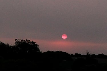
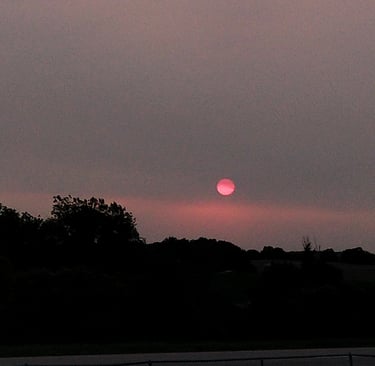
It was the 30th of May and a series of wildfires in the Canadian provinces just to the north were filling the air with a thick and chocking smoke. I had been trying to get the best mileage, gas-wise, as I traveled. For most of the trip I ran on regular unleaded, just to trim the cost of the trip. So, up until this point I had driven with the two front windows down and a slight opening of my sun-roof window.
I drove like this all morning, not realizing the fact that I was breathing in these toxic fumes. No more than seventy miles into North Dakota, my eyes began to burn and I started feeling the impact of the smoke in my lungs. I got as far as Jamestown when I began hearing the reports of the fire and how it was impacting the northern states, moving west to east.
In Jamestown, North Dakota, I made the decision to retreat to the south. On a two-lane road, U.S. highway 281, I made for South Dakota, hoping to evade the smoke that was now a brown haze restricting vision at about a quarter of a mile, at my reckoning. I would head for Interstate 90 to detour around another natural disaster, in the making.
Running now with my windows rolled up and air conditioner on, I made my way south. About mid-day I would stop in Wolsey, South Dakota to get something to eat at a road-side diner. Even a hundred miles south of I-94, the smoke was still thick in the air. I took my time eating in the restaurant’s air-conditioned sanctuary. But even as I went in and out of the building, I could now feel a significant discomfort in my chest.
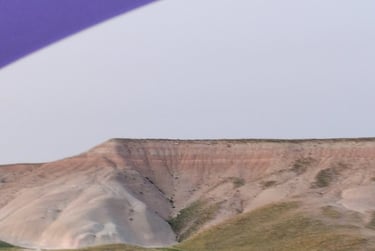
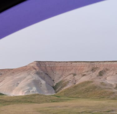
Smoke-filled skies across the Dakotas.
Photo taken around 4 p.m.
Persistently moving on, I made it to Interstate 90 west and accelerated my speed, accordingly. The side road had kept me down to 65 or slower as I passed through the occasional prairie town. I crossed the rest of the state in about two and a half hours, continuing on into Wyoming, traversing the northeastern corner and shooting for Montana and the border of Idaho.
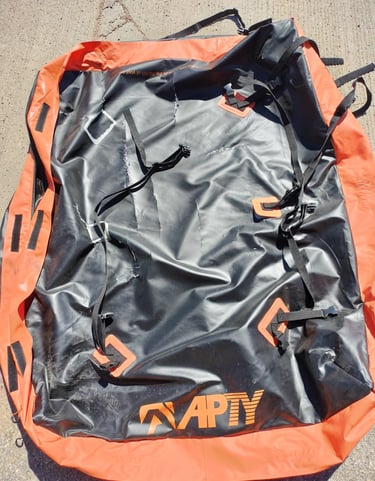
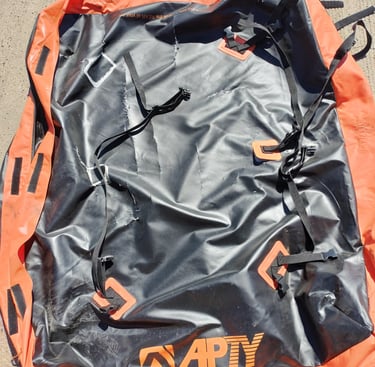
At a fuel stop in Spearfish, Wyoming I noticed that the car top “bag carrier” I had purchased prior to the trip and loaded with about 20 small to medium sized pieces of art was literally coming apart at the seams. Straps had torn loose and the top was shredded like someone had taken a knife to it
Reluctantly, I emptied the paintings that I hadn’t already given away, stacking them in the back of the van. I knew I had to find a replacement as soon as I could.
Shredded car-top carrier
A bit of Wyoming
I remember the landscape becoming more western-like, with the brown hills and flat-topped mesas giving way to the rolling foothills of the Rocky Mountains. As one way to pass the time I began consciously looking for buffalo along the way. I had seen them before in previous trips on I-80, further south in the state of Wyoming. For some reason, although there were the occasional hints of buffalo burgers along the way, I never saw a single bison.
Eventually, I needed a break, I found myself in the valley of the Little Big Horn. I drove around the area to get a feel for Custer’s last view. Almost at once, I realized that strategically, Custer’s men were in a river basin and therefore at a disadvantage. With hills all around and the natives, being very familiar with the territory, it was obvious that they had the high ground. By swooping down from every direction in the surrounding hills, the battle was easily won.
I then stopped in at a nearby trading post and bought some sage and a post card featuring a photograph of Sitting Bull. It was run by the descendants of the Crow nation. I bought some sage and a post card featuring a photograph of Sitting Bull. The whole experience made me wonder why Custer had come so far west to stir up trouble in the first place. The American educational system sometimes skips over these little details!
By the time I got to Billings, Montana the smoke seemed to be thinning out but I continued on, once again denying myself the scenery and driving on into the night. At Bozeman, I could go no further.
Exhausted and feeling significantly weakened, I opted to spend the night at a motel. I practically stumbled into the place. The weather outside had become frigid, somewhere in the forties, at best. The wind was fierce and chilled me to the bone. The clerk gave me a key card and told me to park at the far end of the building. I could use the back door to access my room. At this point, I was out of it. I stood at that back door for several minutes, not knowing where to place the card to gain entry.
Eventually, I gave up and lugging my clothes satchel, laptop, and guitar I walked back to the front of the building and once again stumbled in. I must have made a commotion, (it was around 11 p.m.), and the clerk came out again to see me struggling with my gear. We put it on a baggage cart and he pulled it down the interior hall until we came to my room, just inside the back door.
He showed me how to use the card to access the rear entrance. He then turned and went back down the long hallway, pulling the dolly behind him. I knew something was wrong with me physically, at this point. I tumbled into the bed and soon fell asleep
I woke up relatively early the next morning. I had generally lost track of the actual time due to the ongoing changes in the time zones. It didn’t matter. I was still feeling very weak and I knew I needed to have a doctor check me over. I showered and then headed out.
Recalling my “fuel crisis” in getting across the Appalachian Mountains, I made a pit stop in Missoula, Montana, acquiring a tank full of gas, some lunch and poked around that base-of-the-mountains community until I found an auto parts store. There I acquired a dashboard mounting device to hold my phone. I wanted to get some hands-free videos as I traveled onward.
It had always been my intention to visit a friend now living in Spokane, Washington. She, like myself, is an ex-vet and had made use of her local VA medical center. The medical center would have to be my first destination. I got back into my van like a wounded man throwing himself up and into the saddle of a faithful horse that knew its way home.
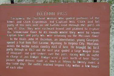
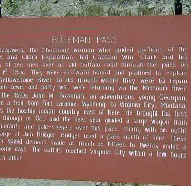
As I drove, I remember thinking how well carved out the highway was as it wove through the highest Interstate pass in the nation. This likely paralleled one of the routes taken during the Lewis and Clark expedition some two hundred and twenty-two years prior. Now it was Interstate 90.
More than 30 men, including a team of surveyors and the now famous Sacajawea, their naïve American interpreter and diplomat to the various tribes encountered along the way, would cross this same pass. It would have been far more precarious, given the lack of a good flat thoroughfare. And Sacajawea was toting her baby, ta boot!
Rocky Mountain Road Interstate 90 Information sign
Idaho was the Rocky Mountains. Spokane, Washington, although still at a fairly high altitude, (2000 feet), was the end of it. I rolled into the city, wondering again if I should stop in at my friend’s house first, but ultimately decided against it. As it was, I was smart in doing so. The clinic closed at 7p.m. and it was almost 6:30. I parked out front. and with the use of my cane, shakily made my way inside. After a half an hour of triage and examinations by three different doctors they elected to check me into the hospital. I would stay there for the next three days.
Although a relatively small facility, this Veteran’s Administration Medical Center was perhaps one of the most modern and well-run facilities I had encountered over the years. The doctors and nurses, therapists and support staff were very knowledgeable and always kind and reassuring. Most of the intervention focused on clearing my lungs. Nebulizer treatments three times a day did much to restore my energy.
The doctors also informed me that in crossing the Rocky Mountains I had reached altitudes as high as 5,702 feet. This had put an extra strain on my heart which had begun beating very erratically, as it was already struggling to provide oxygen to my entire body, further increasing my presenting symptoms.
While there, my friend Ingrid, came and went, bringing comfort and running small, helpful errands. Once discharged, I spent another three days as her guest, furthering my recovery.
Without going into details, she had recently endured her own medical problems and was still in therapy as a result. I was glad to know that she was making steady progress in her own recovery. While there, we caught up on all of the recent events in our lives, went out to eat a couple of times, and watched old movies. Needless to say, I rested a fair amount while there.
Ingrid would further assist me in finding and purchasing a new car-top carrier to replace the bag carrier that had shredded in the middle of South Dakota. She had found it on Facebook Marketplace and although it didn’t have all of the mounting pieces, I tied it down securely and it made the rest of the trip with its contents intact.
My friend Ingrid